1964-66 - Formulation of a Constructive Hypothesis Based on a Search of the Integration of Building and Urbanistic Standards
Thesis Work by: Jorge Rigamonti
Facultad de Arquitectura y Urbanismo, Universidad Central de Venezuela, Caracas
Awards: “Best Thesis” award from the Colegio de Arquitectos de Venezuela at the Third Biennial of Architecture, 1967.
Exhibited at: The International Union of Architects U.I.A. Congress in Prague, Czech Republic, and the World Design Science Decade exhibition at Bloomsbury Square, London, UK, invited by Architectural Association School, 1967.
Synopsis
Starting from the observation of the two-dimensional urban grids that human civilization has developed over the territory, such as the Colonial block of 100 m x 100 m, this study explored the continuous (three-dimensional) subdivision of space at various scales through principles similar to those that led to the differentiation between a street, an avenue and a highway. To that end, using Buckminster Fuller’s studies of geometrical structures (i.e. polyhedrons) as a starting point, it was sought to define a spatial module that could be repeated in space in a fashion similar to a mineral crystal or a body tissue cell. The resulting integration of architecture and urbanism, which is in sharp contrast with the conception of buildings as isolated entities, could prove a more efficient way to develop the future high-density metropolis, allowing vertical segregation between pedestrians and ground transportation.
As an schematic hypothesis, a system made of three grids was explored: a grid “B” of intermediate urban scale with nodes every 1,000 m, articulated into the territorial scale through a grid “C” with nodes every 10,000 m, and into the local urban scale through a grid “A” with nodes every 100 m. Grid “B” was made of a system of public transportation (i.e. subway) and highways, with parking buildings that “filter” the flow of private vehicles to grid “A”. Also, grid “B” incorporates the main urban fabric, composed of low-rise high-density buildings with “specialized exchange points” (areas with a specific primary use such as governmental, commerce, or other) located above the transportation nodes every 1,000 m. That grid with both pedestrian and ground transportation ways would enable to occupy the land of the modern megalopolis in a more rational way, with well delimited spaces for parks, agriculture, and the traditional city that could finally be preserved. The “C” grid, of interregional and continental scale, would be composed of an autonomous and interconnected system of railways, highways and utility lines (electricity, water, and other).
The proposed new developments would sit on stilts to enable the passage of the transportation and utility grids underneath, would be composed of pedestrian platforms and buildings based on a flexible industrial manufacturing and assembly system, and would be placed within an octahedron-shaped macro-structure that allows the orthogonal subdivision of space, while giving structural support and services to a micro-structure of pre-fabricated post-tensioned panels that could house a variety of uses: from large spaces such as an auditorium, to small spaces such as housing. Given the ephemeral nature of modern construction, the development would include provisions to disassemble and reuse both the micro and the macro-structures, thus making way for evolving technologies.
Text in this page is co-licensed under the Creative Commons Attribution-ShareAlike 3.0 Unported License (CC BY-SA) and the GNU Free Documentation License (GFDL) (unversioned). Images in this page are licensed under the Attribution-NonCommercial-ShareAlike 4.0 International (CC BY-NC-SA 4.0) license, unless otherwise specified in the caption of the image.
Sinopsis (en español) - Formulación de una hipótesis constructiva a través de la búsqueda de integración entre estándares edilicios y urbanísticos
A partir de la observación de las retículas urbanas bidimensionales que la civilización humana ha desarrollado sobre el territorio, como la cuadra colonial de 100 m x 100 m, este estudio explora la subdivisión (tridimensional) continua del espacio a diferentes escalas a través de principios parecidos a los que en urbanismo producen la calle, la avenida y la autopista. Con tal fin, partiendo de las experiencias de Buckminster Fuller con estructuras geométricas como los poliedros, se buscó definir un módulo espacial que pudiera repetirse en el espacio tal como los cristales minerales y las células en los tejidos orgánicos. La integración resultante entre arquitectura y urbanismo, que contrasta con la concepción del edificio como entidad aislada, permitiría afrontar potencialmente de manera más eficiente el desarrollo de futuras metrópolis de alta densidad, permitiendo la segregación vertical entre el peatón y los medios de transporte terrestre.
Se propuso a manera de hipótesis esquemática, un sistema compuesto de tres redes: una red “B” urbana intermedia con nodos cada 1.000 m que debía articularse a escala territorial con la red “C” con nodos cada 10.000 m, y a escala urbana local con la red “A” con nodos cada 100 m. La red “B” estaba formada por un sistema de transporte público (Metro) y autopistas, con estacionamientos adyacentes que “filtran” el paso de vehículos privados hacia la red “A”. También sobre la red “B” se desarrollaría el nuevo sistema urbano, basado en edificaciones de alta densidad y baja altura, con “puntos de intercambio especializados” (áreas con un uso principal específico como gubernamental, comercial u otro), coincidiendo con los nodos de transporte cada 1.000 m. Esta nueva malla con circulaciones peatonales y de transporte coincidentes pero disgregados permitiría la ocupación del territorio de la megalópolis moderna en una forma más racional, liberando claramente espacios para los parques, la agricultura y la ciudad tradicional que finalmente podría ser respetada. La red “C” interregional y continental sería un sistema autónomo e interconectado de ferrocarriles, autopistas y red de servicios infraestructurales (electricidad, agua y otros).
Las nuevas construcciones ubicadas sobre pilotes para permitir el paso de las redes de transporte y servicio, contendrían plataformas peatonales continuas y edificaciones basadas en sistemas constructivos industrializados y flexibles, ordenados en una macro-estructura espacial basada en el octaedro que permite la subdivisión ortogonal del espacio, dando soporte estructural y de servicios a una micro-estructura de paneles prefabricados y postensados en obra que albergan los usos concretos para la megalópolis moderna: desde grandes auditorios hasta pequeños espacios para la vivienda. Considerando la condición efímera de la construcción moderna, tanto las micro como las macro-estructuras debían ser desmontables y recuperables para dar paso a tecnologías en constante evolución.
El texto de esta página tiene una licencia compartida bajo la Creative Commons Attribution-ShareAlike 3.0 Unported License (CC BY-SA) y la GNU Free Documentation License (GFDL) (sin versiones). Las imágenes en esta página tienen licencia bajo la Attribution-NonCommercial-ShareAlike 4.0 International (CC BY-NC-SA 4.0) license, a menos que se especifique lo contrario en el título de la imagen.

Sketch of a hypothetical grid system over the Venezuelan city of Valencia. To accomodate to the topography, the larger and intermediate grids vary from 5x5 to 15x15 km2 (corresponding to Grid "C" of the description), while the smaller grid shown is about 1x1 km2 (corresponding to Grid "B"). A comparison with Le Corbusier's 7 V system is made.

Top view of the roads grid A (streets), B (avenues) and C (highways). The right image shows a highway intersection, local streets and avenues access ramps, and parkings' circular access ramps.

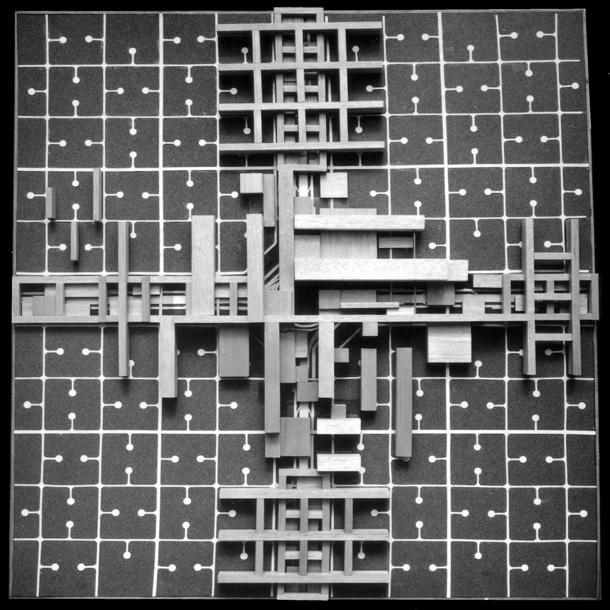
Top views of the grid system models. The right image shows the buildings that sit on top of the highway intersection.

Grid system model showing how the buildings themselves form 3D grid macro-structures. The highest density constructions are placed above the main intersection nodes.

Preliminary sketch of the macro-structure that provides structural support, utility lines, and pedestrian interconnection (through walkways at different levels) for the buildings placed within the gaps of the macro-structure.

Illustration of possible macro-structures that make the urban 3D grid system.

Grid models with 3d grid macro-structures. The right image shows (to its left) some buildings inserted within the macro-structure.

View of polyhedron shapes considered to form the base spatial module for the "continuous subdivision of space" (which could be repeated in space in a fashion similar to a mineral crystal). The tensile octahedron (in the bottom left corner) was selected as it allows the orthogonal subdivision of space.

View of the standard parts and assembly (node inspired by K. Wachsmann's) of the proposed octahedron macro-structure element.

Axonometric view of a macro-structure base module (using tensile cables, as an alternative to cylindrical rods) and the inner micro-structure (floor and wall panels) for apartments. The cables describe 8 octahedron outlines, but allow the orthogonal subdivision of the internal space.

Structural model of the macro-structure base module made of 8 octahedron structures.
Model of the macro-structure base module with the inner "micro-structure" floor and wall panels for apartments.
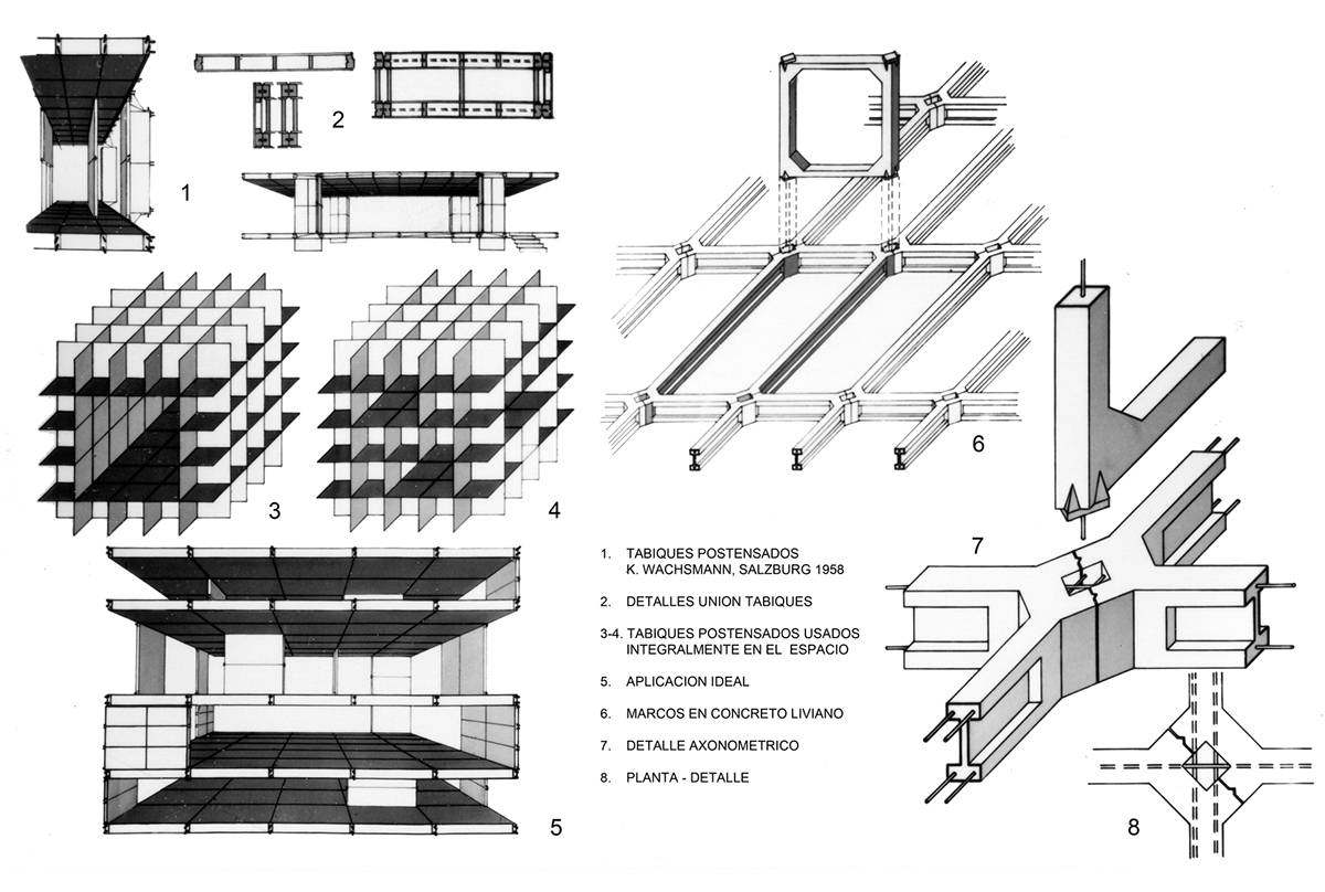
View of K. Wachsmann's inspired post-tensioned prefabricated panels and supporting structure to be used for the micro-structures.
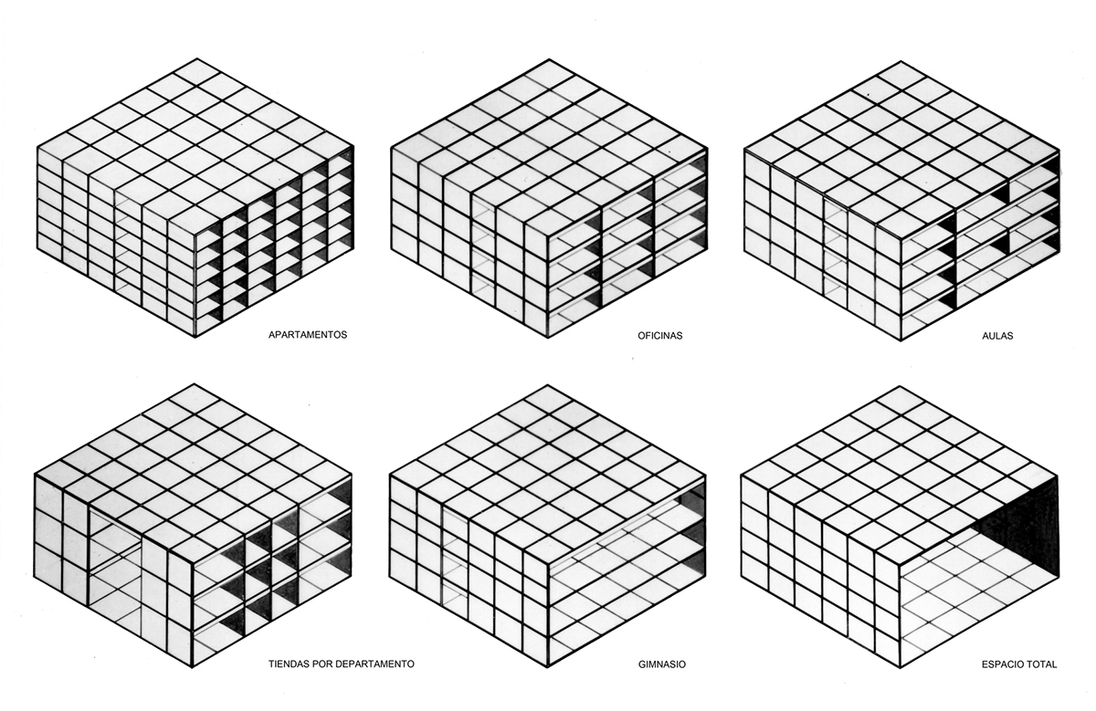
Alternatives for internal space subdivision of the base module: apartments, offices, classrooms, department stores, gym, and the total space.
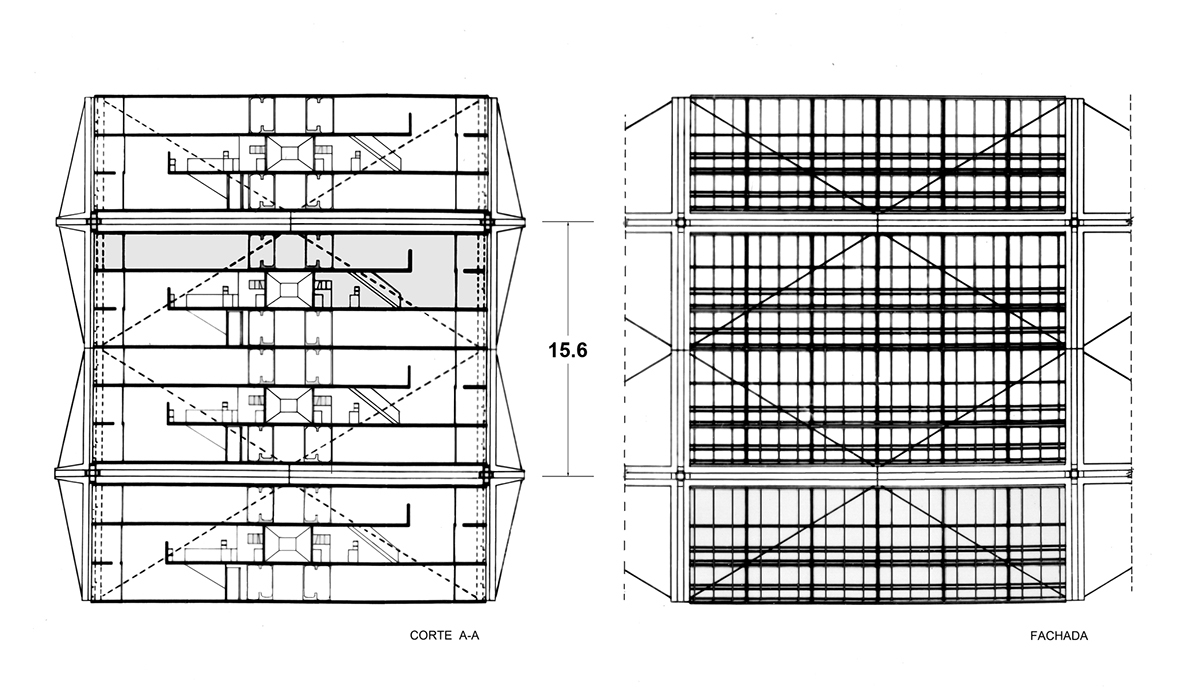
Side section and view of the base module showing 8 apartments, each of which has 2 floors. From each entrance level, access to 2 apartments is shown; the apartment to the left has a lower floor, while the one to the right has an upper floor.
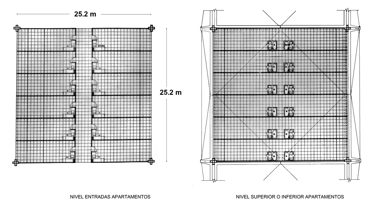
Left image: Floor plan of the apartments entrance level, showing the kitchen area. Right image: Floor plan of the apartments upper or lower levels, showing the bathrooms.

Floor Plan of the "upper" and "lower" apartments. The entrance to both apartments are at the same level; however, the rooms of the left apartment are located in the lower floor, while the rooms of the right apartment are located in the upper floor.

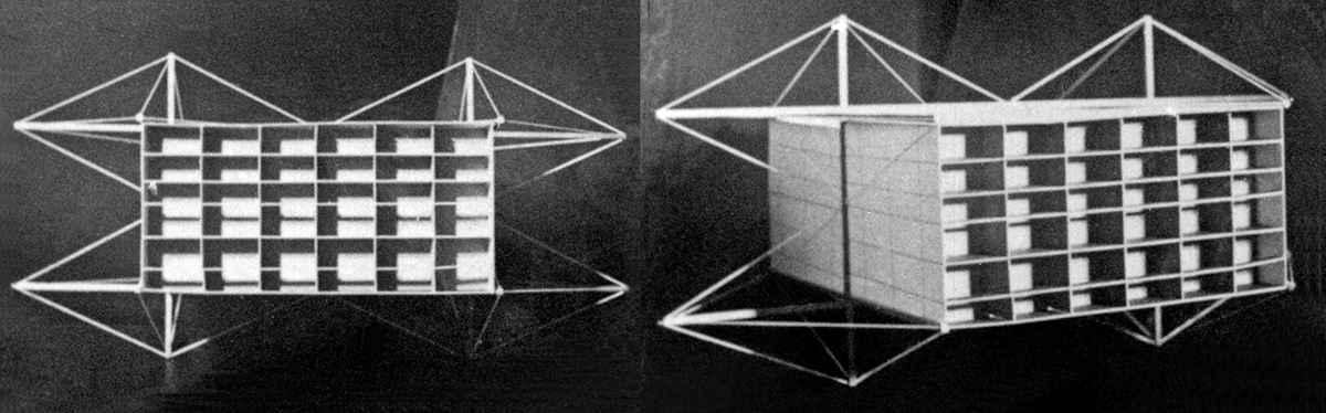
Skyscraper sample macro-structure made of multiple octahedron elements.

Large public space sample macro-structure made of multiple octahedron elements.

Sample macro-structure made of multiple octahedron elements. The middle opening could enable the passing of roads under the structure.
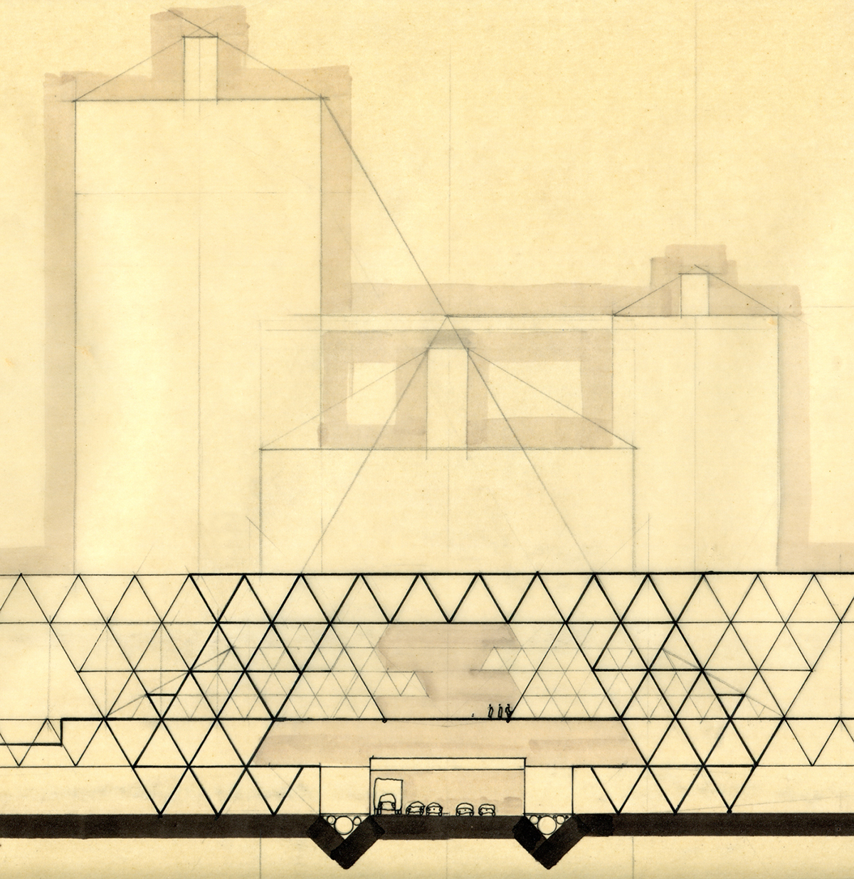
Preliminary sketch of a hypothetical macro-structure with roads and utility lines passing underneath, and a pedestrian walkway in the middle.

Preliminary sketch of a roads "exchange node" with access ramps from/to the avenues, streets and parkings. Macro-structures with buildings, pedestrian walkways and squares, could be located above such interceptions.

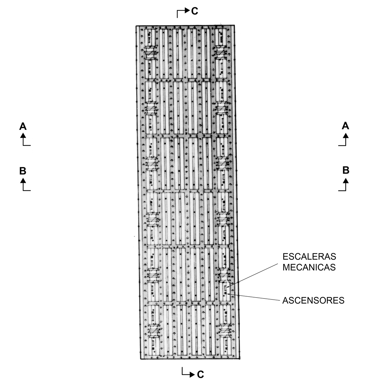
Plan view sketch of a macro-structure platform that sits on top of a roads "exchange node", accommodating parkings, sports arenas, cultural centers and shops. The local streets and avenues at ground level trace the urban grid.

Plan view of the highway level (-6.00 m) with adjacent parkings for trucks and warehouses.

Plan view of the ground level (0.00 m) with avenues, streets, short-stay parkings, and access ramps to residents parkings.
Plan view of the 3 main parking levels (+2.50 m, +5.00 m, and + 7.50 m).

Plan view of the "monthly services" level (+10 m) of the metropolis (cultural center, library, shops, restaurants, cinema, theater, squares, and more).

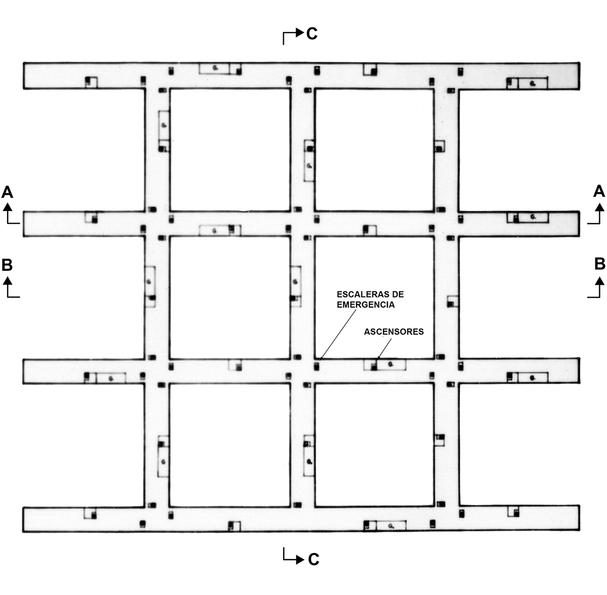
Plan view of the "daily services" level (+40 m) of the metropolis (shops, offices and school).
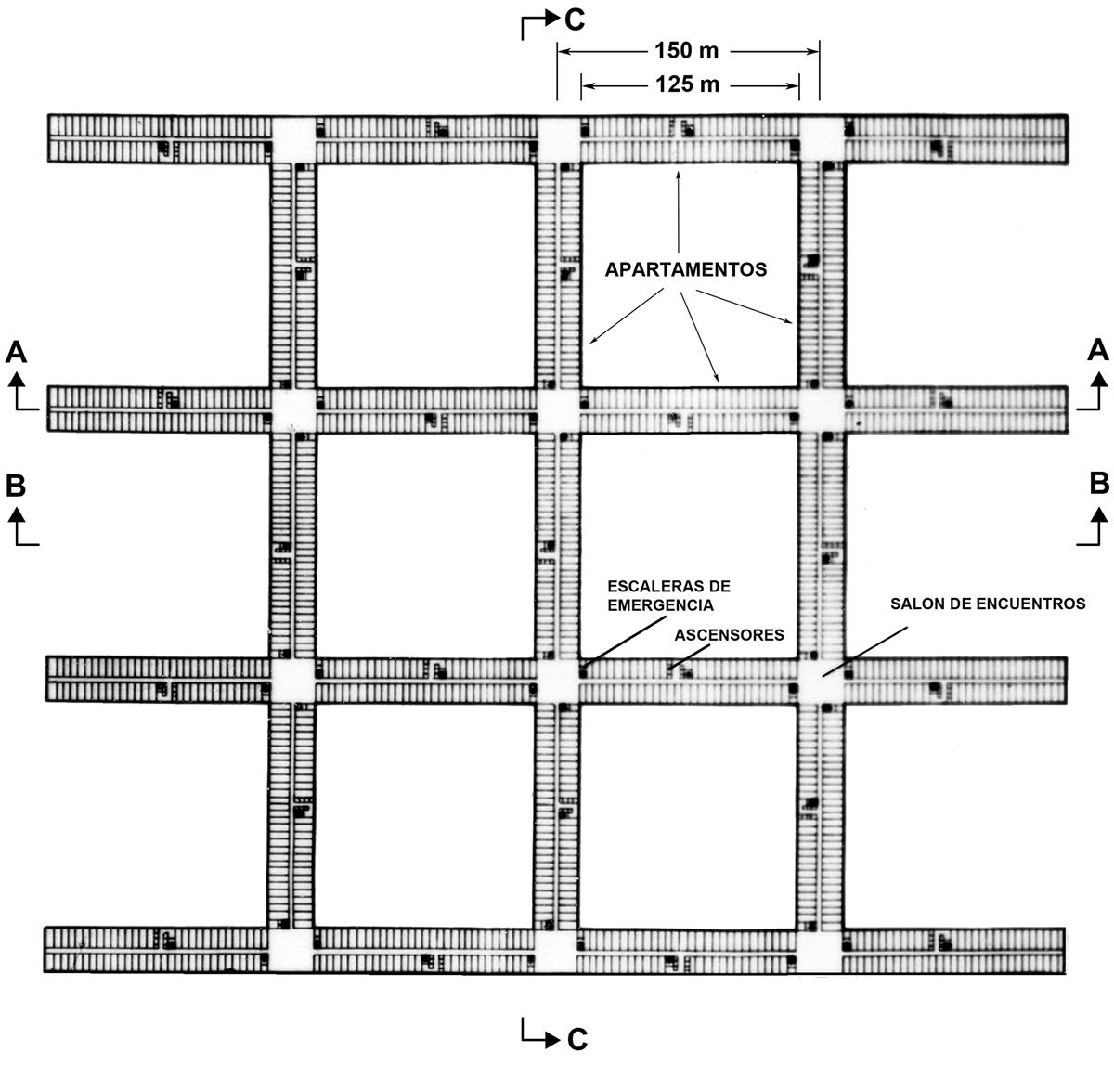
Plan view of a typical apartments level (the 1st apartment-only level starts at +47.50 m in the cross-section below).
Plan view of a typical roof level (+77.50 m in the cross-section below). This level includes open-sky walkways, child nurseries, solariums, gardens, and coffee shops.

Cross section views of a multi-functional macro building. Notice the highway crossing at the underground -6.00 m level, the streets crossing at ground level (0.00 m), and the pedestrian walkways at 3 levels (+10.00 m, +40.00 m, and +77.50 m).

Conceptual models of the buildings that form the 3D urban grid.

Picture collage: public square surrounded by the buildings built with the standard modules, one of which is being transported by a hypothetical mega helicopter.

Top view of the grid model with buildings repeated to illustrate the larger urban grid (the above area is 7 x 4 km2). Gaps in the grid could enclose parks and other green areas.
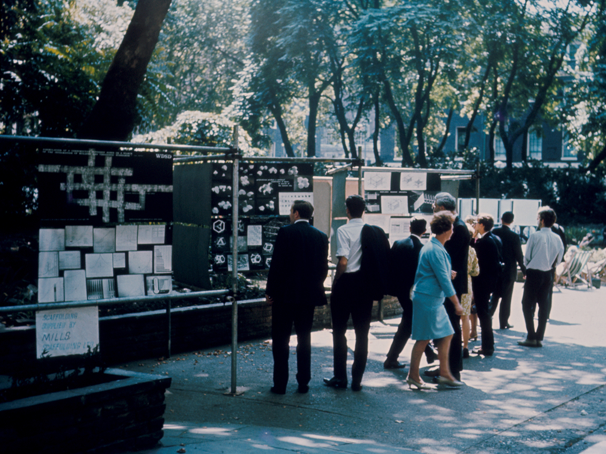
Picture of the thesis panels at the World Design Science Decade exhibition held at Bloomsbury Square, London, UK, 1967.

Picture of John McHale, Jorge Rigamonti and Richard Buckminster Fuller (from left to right) at the World Design Science Decade exhibition held at Bloomsbury Square, London, UK, 1967. McHale and Buckminster Fuller recommended Rigamonti's work for the London exhibition, and for The International Union of Architects U.I.A. Congress in Prague, Czech Republic.
